Trip Facts
Trip Points
Kathmandu-Besisahar-Bahundanda- Chyamche-Dharapani- Pisang- Manang-Khangsar- Besi Khola-Tilicho Base Camp-Thorong Phedi-Muktinath-Jomsom Kagbeni- Pokhara-
Duration
37 Days
Max. Altitude:
7,134m
Group size
Min. 2 – Max. 12
Best Time for Visit
Sep To Dec and Feb to May
Activity
Expedition
Trip Guide & Porter
Experienced | Licensed | Strenuous
Meals
Breakfast, Lunch Dinner
Accommodation
Luxury Hotel/Guest house
DIFFICULTY
Difficult
LOCATION
Tilicho
Departure From
Kathmandu, Nepal
Highlights
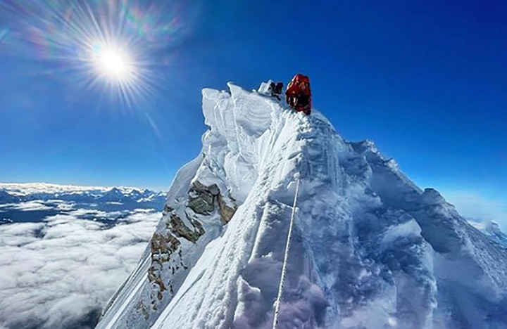
- Summit of Tilicho Peak (7,134 meters)
- Tilicho Lake Experience
- Cultural Exploration
- Diverse Landscapes
- Technical Climbing Challenge
- Stunning Himalayan Views
- Rich Biodiversity
Overview
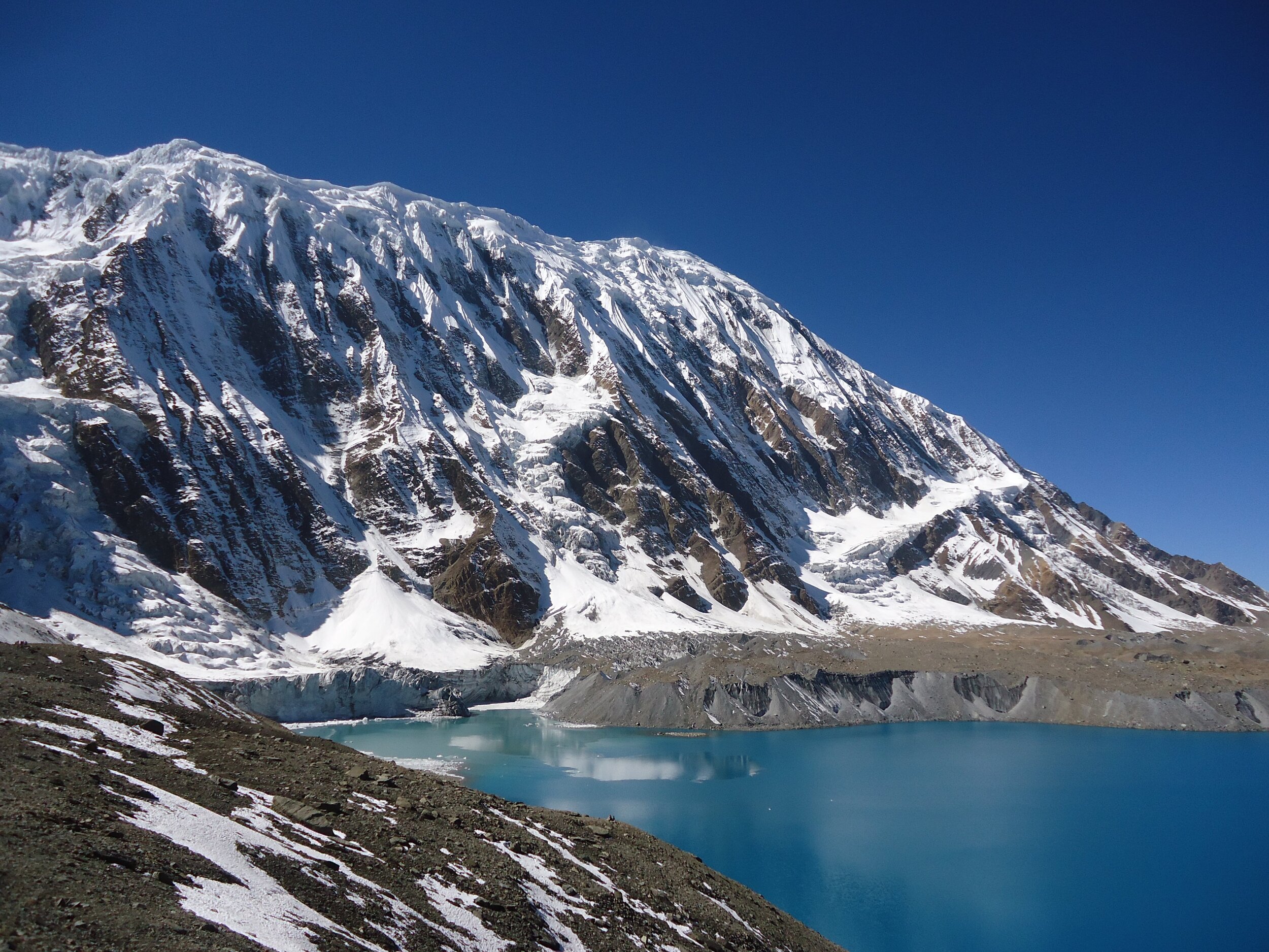
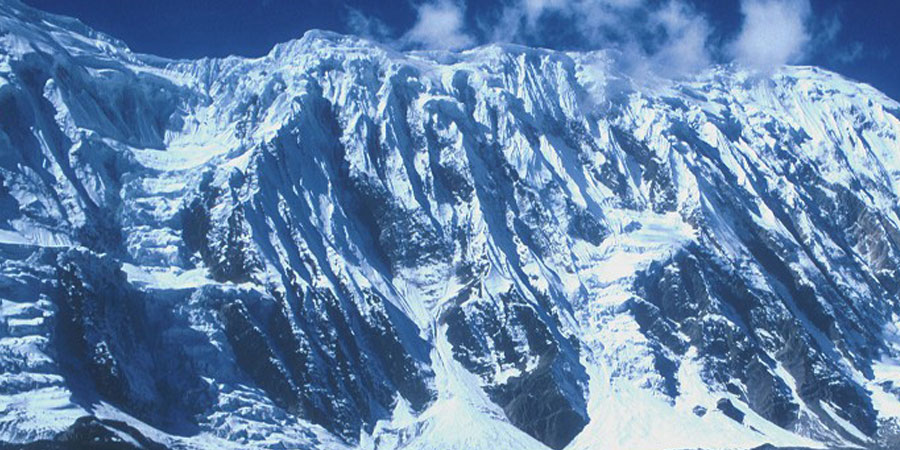
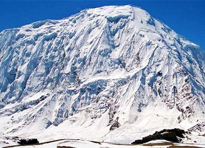
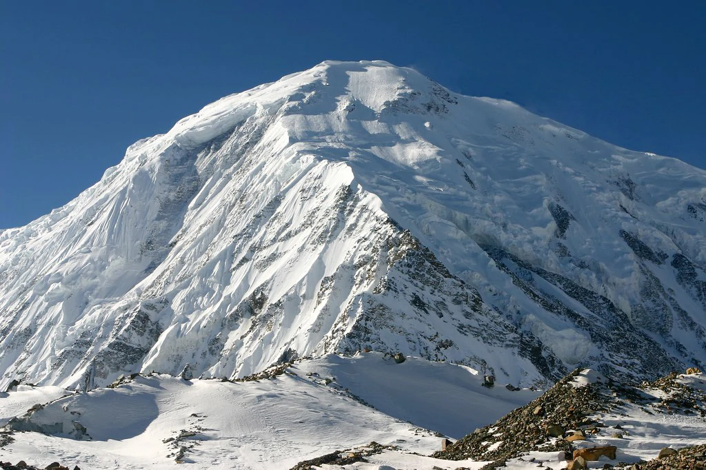
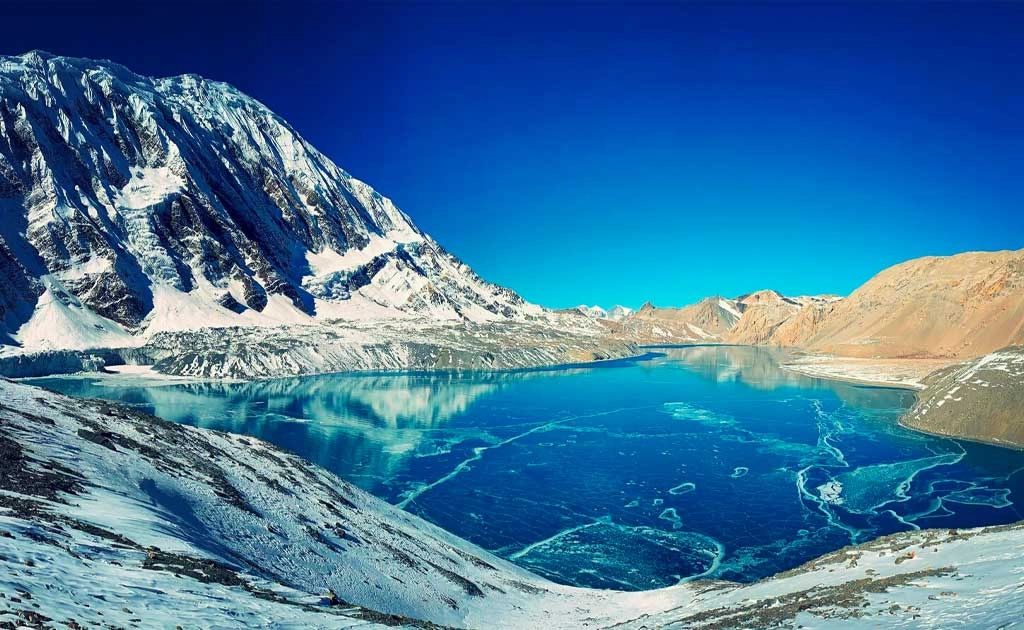
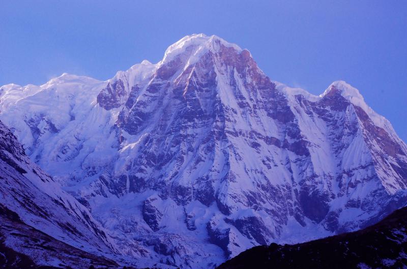
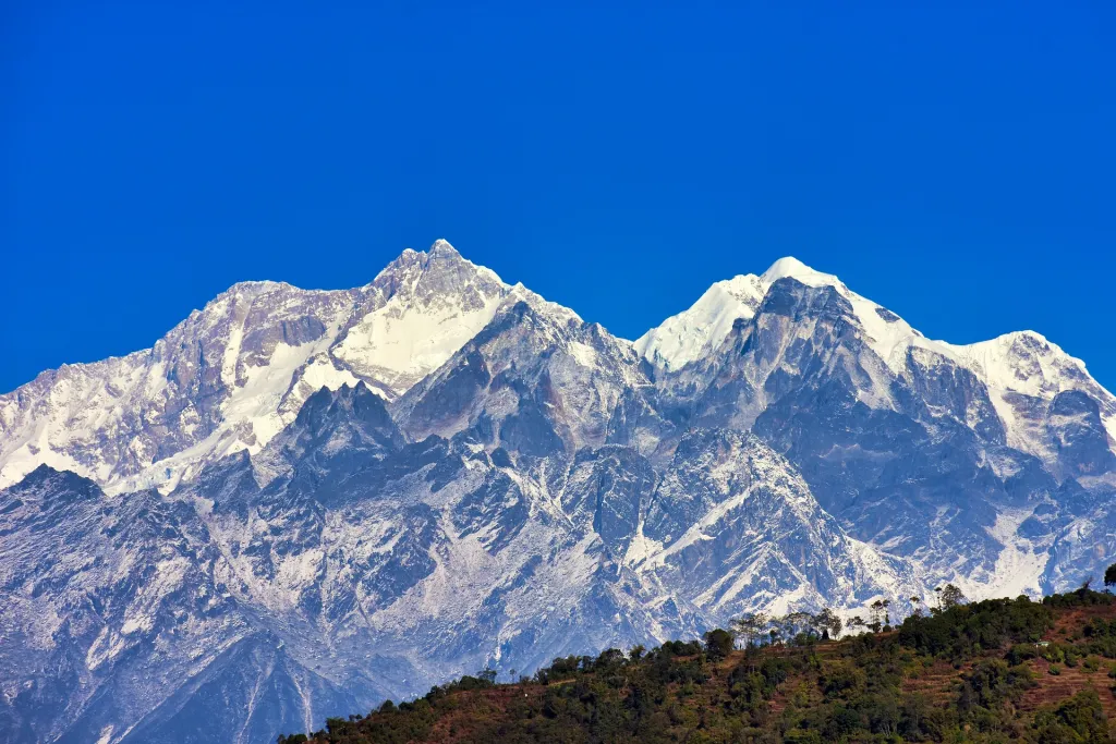
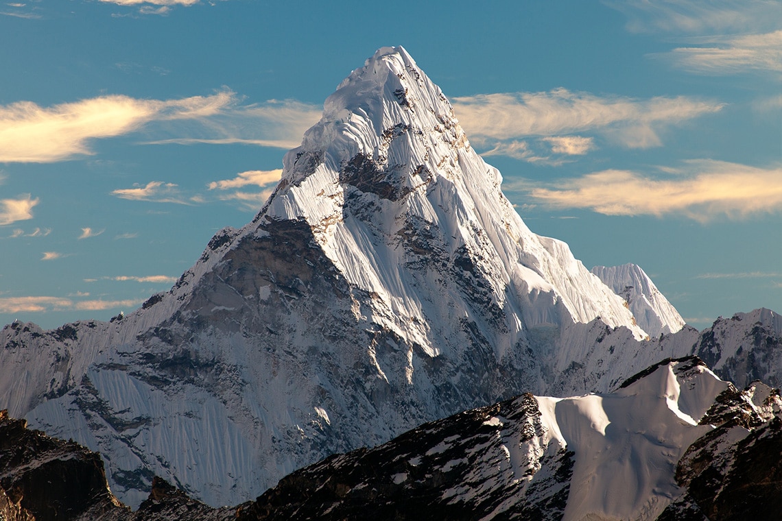
The Peak Tilicho situated at the north of Manang in Annapurna Region. This peak is towers at the height of 7134m in altitude. Tilicho Peak’s northeast ridge covered with snow majestically towers the high Kali Gandaki valley to the west and the Marshyangdi Valley to the east, while the hidden pro- kingdom of Mustang lies just few miles to the north. Maurice Herzog reported Tilicho in 1950 during his exploration of Annapurna. French climber Emanuel Schmutz climbed peak Tilicho for the first time via Northwest Shoulder, which reaches the shores of Lake Tilicho. This is a standard climbing route of the peak with the Base Camp (4800m) located on the Northwest end of the lake.
Tilicho Peak Expedition is a technical climb and not so easy one. We follow the classic route of Annapurna circuit trekking up to Manang and then proceed towards Tilicho Lake to approach the mountain. There will be three high camps established in the approach to the summit of Peak Tilicho. The climb is very straightforward from the Base Camp to Camp 1 (5800m) on a shelf below the Northwest shoulder along on 50deg mixed rock and ice 590m route. Camp 2 (6200m) is located on the shoulder and accessed via 55deg 450 m snowfields. The shoulder itself is also a 55deg 800m snowfield with a low objective danger and very low exposure due to very large width of the shoulder. Climbing Tilicho Peak with fixed ropes is required on 40 degrees slope to reach Camp II at 6300m Summit approached with climbing on some stretches of 60 degrees slope.
A standard access to the Base Camp of Tilicho Peak is through Besishahar via Marsyangdi valley within 10 days trek and affording an excellent acclimatization. After the Tilicho Peak climb one can fly-out from Humde, only one day hike from the Tilicho Base Camp or from Jomsom with 3 days hike via Thorong La pass (5416m). Tilicho Base camp is also accessible from Kali Gandaki valley through difficult Mesokanto Pass (5300m). The view from Tilicho is breathtaking on Annapurna massif, Dhaulagiri, Tibetan plateau and down to the deepest valley in the world the Kali Gandaki valley.
There are two ways to reach up to Base Camp of Peak Tilicho. The Peak expedition starts up with a drive Besishahar, followed by several days trekking to Base Camp as well as another way can fly from Pokhara to Jomsom and start further. However, we choose the first idea as this allows enough time for acclimatization and less difficulties for taking all the logistics. The views on the routes are breath taking; anything that can surpass your imagination. What you see is Tilicho Peak and the azure and peaceful Tilicho Lake below. It is a glacial lake and unfriendly to marine life. People say they often find marine fossils (shells) that probably support the fact that the Himalayas were once beneath the sea.
We set up the base camp for Tilicho Peak Climbing near the lake some of days will be rest celebrating the Puja by Buddhist priest. Tilicho stands as a daunting task above the camp, which is on a moraine. From the Tilicho base camp (around 4400m) we set out for our final goal – Tilicho 7,134m as seen from near the Base Camp.
- Base Camp to Camp (I) – Climbing route is straight steep 70º / 90º
- Camp (I) to Camp (II) – Climbing route is strait steep 90º with ice vertical.
- Camp (II) to Camp (III) -Climbing route is steep to get summit 40º/ 60º or Max. 70º
Tilicho Peak Expedition Base Camp Service
In the Base Camp
- We provide very professional, helpful and friendly service from Kathmandu to the ABC and during the climb. Our objective is to provide a high quality, helpful, safe, friendly, stress free and comprehensive service to maximize summit opportunity. We offer wide range of services from Base Camp logistics to fully guided climbs with individual climbing Sherpas helping their clients to realize the summit.
- High elevation climbing requires not only a set of climbing skills and high fitness level but also the ability to cope with high elevation conditions affecting on ability to function to the extent possible at sea level, where most of climbers are living.
- Our philosophy is to support climbers with the skill and high-altitude genetic adaptation ability of a Climbing Sherpa, who was born and grew up at high elevation, as did his predecessors.
- Tilicho Peak requires set-up of 2 high camps, where the gear, food and fuel have to be carried up. No matter how physically strong and fit one is at the sea level, at high elevation one physical efficiency drops considerably so the team of Climbing Sherpas pooled from all clients will set-up the route and allow you to summit.
- Having personal Climbing Sherpa eliminates arbitrage of the ‘Leader’ to decide who will get limited climbing support on the summit day. In the emergency situation the classic expedition Leader has responsibility for a number of people including themselves with impaired physical abilities due to high altitude, while Climbing Sherpa has only responsibility for his own client and with high physical abilities at high elevation due to natural genetic predisposition and all in cooperation of other expedition Climbing Sherpas. Our Climbing Sherpas are highly trained and experienced climbers doing high elevation climbs in Nepal and Tibet season after season.
- We believe that our philosophy of an expedition with the Base camp Leader-Coordinator and the team of Climbing Sherpas assigned to individual climbers is by far the most efficient and safest way to achieve high elevation summit.
- Our cooks and helpers will prepare and serve three delicious freshly cooked and plentiful meals a day and will ensure that hot and cold drinks are available 24hrs a day.
- We provide spacious expedition quality personal tents for all our clients.
- We also provide dining tent, kitchen tent, toilet facilities, portable shower facilities, and tent accommodation for our staff.
- We provide access to communication including satellite telephone and internet access, solar panels to charge your batteries and UHF/VHF handheld radios on the mountain to maintain communications between ABC and high camps.
- Our Leader and camp manager as well as climbing Sherpas have an extensive experience of multiple climbs above 7000m, so whether you use our full board service or Base camp services you can expect a good advice and support. They also know personally most of other Climbing Sherpas and network together in the Base camp regardless of the operator they work for. Tilicho logistically is a very easy peak, and it is suitable even for a small climbing team.
Tilicho Peak Climbing Full Board Service
- For full board clients, who would be less experienced climbers or single climbers requiring a climbing buddy, we provide personal tent and food at high camps with the climbing Sherpa, who will prepare appropriate meals.
- We provide a personal Climbing Sherpa guide to help the clients to reach the summit. Personal climbing Sherpa will set up high camps including provision of food and fuel and will guide and assist the client on the summit day and if required will set-up fixed rope to ensure the safety.
- We provide the climbing Sherpa with appropriate radio communication to Base Camp from the climbing route. Our Climbing Sherpas will network, cooperate and work with other clients Climbing Sherpas on the route to ensure safety of his client as well as overall expedition team.
- After arriving to the Base camp (4800m), we will take a day or so of acclimatizing rest and preparations including snow practice so that we all develop common understanding, refresh our basic climbing, rescue techniques, and develop our climbing protocol. Our climb protocol follows standard high elevation principles of acclimatization and progressively building higher camps.
Climbing Route
- The standard route begins at the Base Camp (4800m) located at the foot of Tilicho Peak towering 2300m above on the shore of spectacular Lake Tilicho, which will be our water source. The water should be filtered or purified by iodine tablets or boiled.
- The climb is very straightforward. From the Base Camp we do our first scouting acclimatization climb to Camp 1 (5800m) located on a shelf below the Northwest shoulder along on 50deg mixed rock and ice 590m route with some gear for camp 1. We will return to Base Camp for acclimatization rest. During the second climb, we bring the remaining gear and set-up Camp 1, where we stay overnight. The following day we move along 55deg/700m snowfield to Camp 2 (6200m) located on the shoulder and stay there overnight. Depending on the condition, this will be our first opportunity to attempt the summit. We will return to the Base Camp to recover and reinforce our acclimatization.
- Our third round will be a true summit push. We climb to Camp 1, Camp 2 and push for the summit along the Northwest shoulder up a 55deg 800m snowfield with a low objective danger and very low exposure due to very wide shoulder.
- Our program allows 17 days for the climbing period to account for weather and individual physical condition and strength. It gives us plenty of opportunities to carry supplies to camp 1 and 2 and few opportunities of summit push.
Normal Route – Northwest shoulder
- The Northwest Shoulder of Tilicho is a straightforward climb, mainly on snowfields up to 55deg. It has very little objective danger because a wide shoulder very well protects the entire route. Most of the route is on a snowfield with bottom section potentially on a mix of rock and ice. We establish the Base Camp at 4800m on a shore of a beautiful Lake Tilicho.
- Camp 1 (5800m) is located on a shelf below the Northwest shoulder accessed by a gradual climb on snow field from the Base Camp and gaining 300m over 1.5km followed by 50deg 690m route of mixed rock and ice.
- Camp 2 (6200m) is located on the broad Northwest shoulder accessed from Camp 1 by 55deg 400 m snow routes. Summit is accessible from Camp 2 by 55deg 900 m snowfield routes along broad well-protected Northwest shoulder.
Approaches to ABC
From Kathmandu via Besi Shahar
- The trek starts from Besi Shahar, where we drive from Kathmandu and follows Marsyangdi valley with 10 days trek affording an excellent acclimatization opportunity. The access trek is a part of world-renowned trek around Annapurna. It is stunningly beautiful and affords phenomenal cultural experience of Buddhist and Hindu cultures.
- We will follow a standard Annapurna circuit trek to Manang, where we turn off to Tilicho Lake. On the way back we will return to the Annapurna circuit and will follow it via Thorong La pass (5416m) to Jomsom, from where we fly out to Pokhara. On the way we will pass through interesting Buddhist villages with very Tibetan flavor.
From Beni Bazaar via Kali Gandaki Valley
- This route follows Kali Gandaki Valley, the deepest valley on earth but it is not a standard route because it requires negotiating logistically a very difficult Mesokanto Pass (5300m).
Itinenary
Upon your arrival at the Tribhuvan International Airport, one of the Nomadways Adventure representatives will be waiting for you at the airport. As soon as you complete your Nepal Entry Visa obtaining procedure, we will have a meet and greet, and you will be transferred to the hotel (3-star to 5-star as per request) where you can rest and relax for the day.
Meal :
Breakfast, Lunch, dinner
Accommodation :
At a Luxury Hotel/Guest house
Final equipment checks and permits. Meet with the team and guides. Optional sightseeing in Kathmandu Valley.
Meal :
Breakfast, Lunch, dinner
Accommodation :
At a Luxury Hotel/Guest house
Today we will drive away from the chaotic streets of Kathmandu and head towards Dharapani, the starting point of the trek. Dharapani is nestled amidst the towering peaks of the Annapurna and Mt. Manaslu – the world’s eighth-highest mountain. The path leading to Jagat’s heads northwards, following the Marsyangdi Valley, with Himalchuli and Ngadi Chuli (Peak 29 – 7871m) looming in the distance. As we trek through this region, we will pass by serene villages and lush rice paddies. Following a rocky trail along the Marsyangdi River, we will encounter several breathtaking waterfalls, verdant flora, and fauna. The trail winds uphill until we reach Tal, which means “lake” in Nepali. Tal is the first village in the Manang district and marks a dramatic change in the landscape from the lush beginnings of the trek. As we move ahead, the trail ascends through an impressive, wide valley, with stone staircases leading us toward the village of Dharapani.
Meal :
Breakfast, Lunch, dinner
Accommodation :
At a Luxury Hotel/Guest house/Camp
Today’s path tracks along the Marsyangdi River, making its way up to Timang at an elevation of 2360m and then through dense pine and fir woods. While ascending through the forest, the views of the valley and Annapurna II (7937m) are breathtaking. This is where you start experiencing the sensation of being in the lofty Himalayan mountains. Before reaching Chame, the administrative hub of the Manang District, we will also have the opportunity to witness stunning panoramas of Mt. Manaslu (8156m) and Peak 29 (7871m).
Meal :
Breakfast, Lunch, dinner
Accommodation :
At a Luxury Hotel/Guest house/Camp
We will cover a distance of 13 kilometers or 8 miles and hike for approximately 6-7 hours from Chame to Pisang, which is at an altitude of 3250m. Our journey commences by leaving the village and passing a prayer wheel leading us into a dense pine forest. The Marsyangdi Valley becomes narrower and steeper, and the trail is etched into the vertical rock face. As we move past this point, the valley expands, and we are greeted with a breathtaking mountain vista. The Paungda Danda rock face, which towers over 1500m above the trailhead, is believed by the local Gurungs to be the Gateway to Heaven. We will continue to ascend to Pisang while enjoying this magnificent view.
Meal :
Breakfast, Lunch, dinner
Accommodation :
At a Luxury Hotel/Guest house/Camp
From Pisang, located at 3520m above sea level, the trail spans 12.5 km or 7.76 miles and takes 5-6 hours to complete. As one trek through the upper region of Manang District, the pervasive influence of Tibetan/Buddhist culture can be observed. The locals here primarily engage in yak herding and maize cultivation. Two routes are available after leaving Pisang, both of which follow the Marsyangdi River and converge again in the villages of Mungji and Braga, the latter of which boasts a picturesque monastery. The southern route is a comparatively easy ascent alongside the river, while the northern route entails a more arduous climb along the valley’s north ridge. Nevertheless, the panoramic views of the Annapurna range from the northern route are breathtaking.
Meal :
Breakfast, Lunch, dinner
Accommodation :
At a Luxury Hotel/Guest house/Camp
Today we will take a day off for rest and acclimatization. There are several days walks available that not only provide breathtaking views but also increase altitude. One option is to hike up the hill (with a 400m ascent) behind Manang and visit the monastery. From there, you can enjoy magnificent views of the Annapurna range and observe the enormous icefall cascading from Gangapurna. Another possibility is to undertake a challenging hike to Ice Lake (4500m), which takes around 5-6 hours and offers stunning views of the area. The perfect conclusion to the day is to sit back and admire the sunset over the Himalayas.
Meal :
Breakfast, Lunch, dinner
Accommodation :
At a Luxury Hotel/Guest house/Camp
On the eighth day of our Tilicho Peak expedition, we will trek from Manang to Siri Kharka, which typically takes 4-5 hours. To begin, we will exit through the western gate and follow the path toward the river. From there, we will continue along the trail, which runs along the southern side of the coniferous forest. After passing through Kangsar village, we will arrive at Siri Kharka. Along the way, we will have the opportunity to visit a monastery and take in stunning views of Gungang Himal and Mt. Chulu, which will serve as great sources of motivation. We will spend the night at Siri Kharka.
Meal :
Breakfast, Lunch, Dinner
Accommodation :
At a Luxury Hotel/Guest house/Camp
On the ninth day of our Annapurna region trek, we’ll embark on a moderately challenging journey toward the Tilicho base camp. The path is narrow and strewn with loose rocks, making it susceptible to landslides. Therefore, we must tread cautiously, which can make the trek tiring. Despite this, we’ll be rewarded with stunning views of rock formations and snow-covered peaks, including the majestic Tilicho Peak.
Meal :
Breakfast, Lunch, Dinner
Accommodation :
At a Luxury Hotel/Guest house/Camp
From day 10 to day 20, the climbers will be engaged in the arduous task of scaling Tilicho Peak, which stands tall at 7134 meters or 23,406 feet. This period of ten days will be dedicated to the rigorous process of climbing and summiting the peak.
At a towering height of 7134 meters, Tilicho Peak is a formidable challenge for even the most seasoned climbers. The climb is fraught with danger and requires much technical skill and endurance. The journey to the summit tests physical and mental fortitude, as the climbers must contend with steep inclines, treacherous terrain, and unpredictable weather conditions.
Meal :
Breakfast, Lunch, Dinner
Accommodation :
At a Luxury Hotel/Guest house/Camp
Day 21 of your trek brings an exciting adventure from Base Camp to the picturesque town of Manang. Situated at 3520 meters or 11,550 feet above sea level, Manang provides an ideal location for trekkers to adjust to the high altitude and enjoy the scenic beauty. The trek will take approximately 5 to 8 hours, and the rugged terrain may pose some challenges. However, the breathtaking panoramic views of the mountains and surrounding landscapes will make each step worthwhile.
Once you arrive in Manang, you can unwind at a cozy teahouse for the night. The teahouse offers a hospitable and warm environment, and the local cuisine is not to be missed. Take some time to rest and rejuvenate after a long day’s trek and explore the unique cultural traditions of the town.
Meal :
Breakfast, Lunch, Dinner
Accommodation :
At a Luxury Hotel/Guest house/Camp
On Day 22 of your trek, you’ll go from Manang to Chame, nestled at an impressive elevation of 2650 meters (8695 feet) above sea level. Brace yourself for a trek that could take 4 to 8 hours, depending on how fast you move and the weather conditions. During this journey, you’ll gradually lose an elevation of 870 meters, so get ready for some downhill walking. Once you reach Chame, you’ll experience staying at a teahouse, a popular type of accommodation along Nepal’s famous trekking routes. Teahouses are basic but cozy, offering everything you need for a good night’s sleep, such as a bed, blankets, and food. But more than that, they provide a unique opportunity to get to know the local culture and interact with other hikers worldwide.
Meal :
Breakfast, Lunch, Dinner
Accommodation :
At a Luxury Hotel/Guest house/Camp
On the 23rd day of your adventure, a scenic drive from Chame to Kathmandu awaits. The journey typically takes 10-12 hours, and you’ll experience an elevation loss of 1250m. Kathmandu, a bustling city that sits at an elevation of 1400m/4590 ft, is the final stop for the day, and numerous hotels are available for a comfortable overnight stay.
Nestled in the Himalayas at an altitude of 3,519 meters, Chame is a charming town in the Manang district of Nepal. The town is renowned for its stunning location along the Marshyangdi River and the Thorong La pass leading to the Muktinath shrine. Chame is well-connected by jeep roads and trekking trails, making it a popular destination for adventure enthusiasts. In addition, the town is an important trading hub for the locals, contributing to its unique cultural significance.
Meal :
Breakfast, Lunch, Dinner
Accommodation :
At a Luxury Hotel/Guest house/Camp
On the 24th day of the itinerary, there will be a day of rest and exploration in Kathmandu. Situated at 1400m or 4590 ft, Kathmandu offers an excellent opportunity for visitors to acclimate to the altitude. The overnight stay will be at one of the hotels in Kathmandu.
Meal :
Breakfast, Lunch, Dinner
Accommodation :
At a Luxury Hotel/Guest house/Camp
Before your flight, a Nomadways Adventure representative will verify your flight tickets and provide transportation to the airport, anticipating the opportunity to cross paths with you again.
Meal :
Breakfast
Cost Includes:
- All airport transfers
- Luxury Hotel in Kathmandu for two nights with breakfast
- All airport taxes
- All necessary paperwork and trekking permits (National Park permit and TIMS)
- An experienced English-speaking Govt. registered trekking guide and local porters to carry luggage (2 trekkers: 1 porter)
- Full meals: Breakfast, Lunch & Dinner of your choice
- Supplementary snacks: energy bar and cookies
- Seasonal fresh fruits desert every day
- Unlimited Chlorine treated Safe Drinking water
- Accommodation: Lodge
- A comprehensive First Aid kit
- Oxi-meter: To check heart rating and oxygen saturation to Everest Base Camp and return
- All government and local taxes
- Trekking equipment: down-filled sleeping bag, walking poles, and duffel bag
- Souvenir: Trekking Route map printed T-Shirts
Cost Excludes:
- Lunch and dinner in Kathmandu
- Hot and bottled drinks
- Electronic device re-charge Wi-Fi
- Hot shower
- Travel insurance and medical evacuation
- Tipping
Equipment
Trekking requires careful selection of gear to ensure comfort, safety, and efficiency on the trail. Depending on the conditions (terrain, weather, duration), the equipment you need may vary, but here’s a comprehensive list of essential trekking gear:
- Backpack
- Capacity: Typically, for a multi-day trek, a 40-60L pack is ideal.
- Fit: Adjustable straps for shoulder, chest, and hip.
- Features: Hydration system compatibility, side pockets for easy access, and a rain cover.
- Footwear
- Trekking Boots: Look for boots with good ankle support, durable soles (Vibram is a popular choice), and waterproof features.
- Trail Shoes: For lighter treks or well-maintained paths, trail shoes may suffice.
- Sock Layers: Merino wool socks or synthetic socks that wick moisture and reduce blisters. Avoid cotton.
- Gaiters: To keep debris, mud, and snow out of your boots.
- Clothing (Layering System)
- Base Layer: Moisture-wicking (synthetic or merino wool) long-sleeve top and bottoms.
- Mid Layer: Insulating layer, such as a fleece or down jacket.
- Outer Layer (Shell): Waterproof, windproof jacket and pants. Gore-Tex or similar fabrics are excellent choices.
- Trekking Pants: Convertible pants (with zippers for shorts) can be useful.
- Trekking Shirt: Lightweight, moisture-wicking, and quick-drying.
- Gloves: Lightweight gloves for warmth, plus an additional heavier pair if trekking in cold climates.
- Hat/Cap: A sunhat or beanie depending on the weather.
- Neck Gaiter/Buff: For sun protection, warmth, or dust.
- Sleeping Gear
- Sleeping Bag: Temperature-rated for the conditions you’ll face. Down bags are warmer and lighter but lose effectiveness if wet, while synthetic bags dry quicker.
- Sleeping Pad: Inflatable or foam pads that insulate from the cold ground.
- Tent: Lightweight trekking tents (1-3 person) that suit your conditions. Some options include 4-season tents if you're trekking in harsh weather.
- Hydration System
- Water Bottles: Collapsible or hard plastic bottles (ensure they’re BPA-free).
- Hydration Reservoir: Camelbak or similar bladder systems for easy access to water.
- Water Purification: A filtration system (e.g., Sawyer, LifeStraw) or chemical tablets to purify water from streams or other sources.
- Food and Cooking
- Stove: Compact gas or alcohol stove for cooking on the trail.
- Cookware: Lightweight pots or pans, often titanium or aluminum.
- Fuel: Compatible fuel for your stove (check for availability in the region you’re trekking).
- Food: Dehydrated meals, energy bars, trail mix, nuts, and fruits. Lightweight, high-calorie, and easy-to-prepare foods are best.
- Navigation Tools
- Map and Compass: Always have a paper map as a backup, even if you use a GPS.
- GPS Device or Smartphone with a Trekking App: Make sure to download offline maps.
- Altimeter Watch (optional): Useful for tracking elevation and route progress.
- Lighting
- Headlamp: Hands-free lighting for night-time use, with extra batteries.
- Flashlight: A backup to your headlamp.
- First Aid Kit
- Include basic supplies: Bandages, antiseptic wipes, blister treatment, pain relievers, and any personal medications.
- Personal Medications: Always bring enough for the whole trip, plus extras in case of delays.
- Sunscreen and Lip Balm: Protect your skin from sun exposure.
- Safety Gear
- Multi-tool/Knife: A good multi-tool (like a Swiss Army Knife or Leatherman) is very useful for repairs and emergencies.
- Whistle: For signaling.
- Emergency Blanket: Lightweight and compact for warmth in case of emergency.
- Firestarter: Matches or a lighter, and waterproof if needed.
- Miscellaneous
- Trekking Poles: Help with balance, reduce strain on knees, and improve traction on uneven terrain.
- Towel: Quick-dry, compact towel.
- Sunglasses: UV protection for your eyes.
- Camera/Smartphone: For documenting the journey, with extra storage or a portable charger.
- Personal Hygiene and Toiletries
- Toilet Paper: Always carry biodegradable toilet paper and a small trowel for digging a "cathole" if there are no facilities.
- Hand Sanitizer: To keep clean without access to water.
- Wet Wipes: For cleaning yourself when there's no shower.
- Biodegradable Soap: If you need to wash, use eco-friendly soap.
- Toothbrush/Toothpaste: Compact travel versions.
- Weather Protection
- Sun Protection: Sunglasses, sunblock, and a wide-brimmed hat for sun protection.
- Rain Gear: A high-quality waterproof jacket, pants, and gaiters, especially if you're trekking in areas with unpredictable weather.
- Cold Weather Gear (if needed): Depending on the trek, you might need additional gear like down jackets, insulated gloves, or even crampons for ice or snow.
- High-altitude Treks: Consider gear for altitude sickness (like Diamox), extra layers for extreme cold, and an oxygen system if necessary.
- Long-distance Treks: You might need additional gear like extra food storage, a larger stove, or a lightweight trekking umbrella.
FAQ's
Tilicho Peak is located in the Annapurna region of Nepal, near the famous Tilicho Lake, one of the highest-altitude lakes in the world. The area offers stunning views of the Annapurna and Dhaulagiri Mountain ranges.
This expedition is classified as very challenging, requiring prior mountaineering experience, excellent physical fitness, and technical climbing skills. Climbers face steep ascents, icy slopes, and high-altitude conditions.
Summit success rates vary, typically around 50–60%, depending on weather conditions, climbers’ preparation, and team support.
Map
Consumer reviews
Similar Trips

Don’t wait any longer. Contact us!

Mail us on

Affiliation