Trip Facts
Trip Points
Kathmandu-Lukla-Namche Bazaar -Tyangboche -Dingboche-Lobuche-Gorakshep-Summit Everest
Duration
65 Days
Max. Altitude:
8,848m
Group size
Min. 2 – Max. 12
Best Time for Visit
Sep To Dec and Feb to May
Activity
Expedition
Trip Guide & Porter
Experienced | Licensed | Strenuous
Meals
Breakfast, Lunch Dinner
Accommodation
Luxury Hotel/Guest house
DIFFICULTY
Difficult
LOCATION
Everest Region
Departure From
Kathmandu, Nepal
Highlights
- Climb the highest mountain in the world
- Fully guided expedition with Sherpa support and max O2
- Climb Lobuche East for acclimatization
Overview
Follow us to the top of the world: we are delighted to offer this once in a lifetime adventure. We provide world-class service from Everest Base Camp (EBC) to all the high camps of Mt. Everest from its South face in Nepal. We take care of you right from the arrival in Kathmandu. The price includes Hotel accommodation, the flight to Lukla in the Khumbu region, the trek to Base camp via Namche and tea house full board service during the trek before arriving to base camp, and of course the services at base camp and at the high camps. Let us take care of all the details – you can fully focus on your climb.
The climbing Guides of our company are highly skilled, regularly reviewed and re-trained and recognized for their training and experience throughout the profession. We only take the most experienced guides and staff on this expedition. This is a serious climb, and mistakes can have serious consequences. This is why we focus extensively on safety and accident prevention for both clients and guides on our Everest expedition. No expedition is without risk and certainly not one to the highest Mountain of the world. However, we implement rigorous safety standards to minimize the risk. We’d also like to highlight that our guides and staff are all employed under ethical standards.
The exploration of Mount Everest has a long and varied history – from the first recognition of the peak to the attempts of Mallory, Irvine, Norton & co and eventually the successful attempt of the British and the impressive solo ascent of Reinhold Messner.
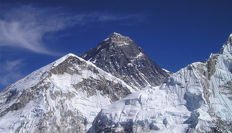
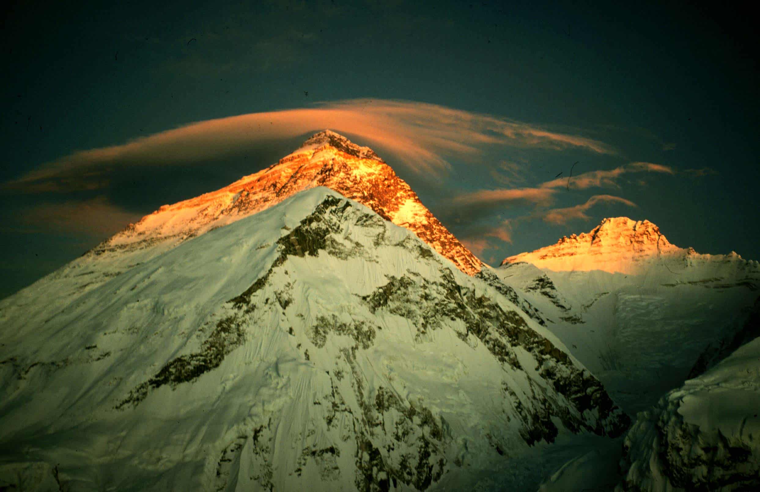
The Sagarmatha (forehead of the sky) in Nepali is known as Mt. Everest throughout the world. With an altitude of 8848m, it is the highest peak on earth. The South face is recognized to lie in Nepal whereas the North face is in China’s autonomous state Tibet. This world’s highest peak was first officially measured in 1856 during the Great Trigonometry Survey of British India government and then known as Peak XV certified with the height of 8840m. With a simple technology and the distance from the mountain, the height was determined with really phenomenal accuracy – only 8m off from the current value of 8848m.
The name of British Surveyor in 1856 was Sir George Everest– the General of British India during the survey period and a somewhat infamous character. Tibet and Nepal were closed to foreigners at the time, so it is reasonable to assume that local names of the mountain were unknown. The name of the highest peak was chosen in his honor, although not without controversy even at the time. The first climbing attempts were not possible until the 1920’s and they ended ultimately in disaster. Success came only in 1953 from the South side on the very same route you’ll be taking for this expedition.
Retrace these historic achievements and write your own history by making an attempt to reach the top of the world. With us as your support crew, everything is possible.
Approaches to ABC from South (Nepal)
The approached on its south side is through the Khumbu region of Nepal leading up to the Khumbu Glacier extending down to Lobuche (4900m). It starts with the flight to Lukla and the trek via Namche Bazaar (3440m), Tengaboche (36600m), Pheriche (4270m), Lobuche (4910m), Gorak Shep (5140m) to Everest South Base Camp (5364m). It takes typically 8 days to reach ABC from Kathmandu.
Climbing Routes South Side
- South route is technically a trekking route with a little objective danger once past the Khumbu icefall apart of few crevasses and seracs bridged by ladders, couple short ice cliffs around camp 3 and rock sections protected with fixed lines. There is an obvious danger of high-altitude sickness complications and changeable, unpredictable mountain weather.
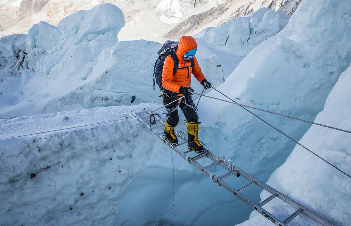
- The Khumbu Icefall is a steep glacier with obvious implication of large crevasses and treacherous unstable seracs making navigation complicated and riddled with high objective danger of falling ice. This is the most dangerous part of the climb. At the beginning of the climbing period, climbing Sherpa set the route through the icefall installing ladders across crevasses and along vertical seracs ice walls for efficient and easy climbing. These arrangements make climb of the Khumbu ice fall possible, efficient and relatively safe especially early morning before the sunrise, when the ice structure is well frozen. Khumbu ice fall is very dangerous in the afternoon due to its western aspect.
- Camp 1 (6065m) is located on the top of Khumbu ice fall; it is a desolate and exposed place mainly used as rest and transition location on the way to camp 2 (6750m). The glacier between camp 1 and 2 flattens but there are still large crevasses close to camp 1, which are also fixed with ladders.
- Camp 2 is located in a lateral moraine at the bottom of west ridge. It is a very safe and sheltered location with tremendous views on Lhotse. All companies set-up their main climbing camp for the duration of climbing period with tents for individual climbers, the kitchen and dining tents. Camp 2 is main acclimatization camp and the base for camp 3 acclimatization climb and the final summit attempt.
- Camp 3 (7100m) is located on small ledge on the Lhotse wall. One has to cross the glacier to the right side before 40deg 600m climb on the compact snow field. The route is safe with couple of short less then 3m ice cliffs, which climbing sherpas set up with fixed ropes.
- Camp 4 (7920m) located at South Col is the last camp; it is easily accessible by majority of climbers without supplementary oxygen. There are two rock sections to navigate before camp 4: Yellow Bands interlayer marble, Phyllis and semi schist rocks and Geneva Spur, an anvil shaped rib of black rocks; they are again set-up with fixed ropes.
- his is when the climb starts, the last section of the southwest ridge. It is steep mostly on the snow with some rock section at the Balconies, nice resting platform. The entire route is setup with fixed ropes, which is crucial for safety of all climbers, who are all affected by altitude with low energy and impaired judgments due to oxygen deprivation in the brain and muscle tissue.
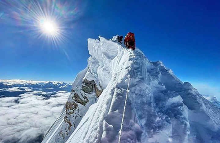
- From the south summit there is knife edge southeast ridge with dangerous overhanging cornices; the most exposed section of the climb between 3050m Kangshung face and southwest face and Hillary step at the end, a series of imposing rock steps often bypassed on deep the snow, a serious avalanche danger
Our Everest Climbing Services
- The Mount Everest is the highest peak of the World 29028ft. (8848m.) through which the climbing toppers feel themselves as the most proud and adventurous person of the World. Sir Edmond Hillary and Late Tenzing Norge Sherpa first climbed this peak in May 29, 1953, after their long time’s effort.
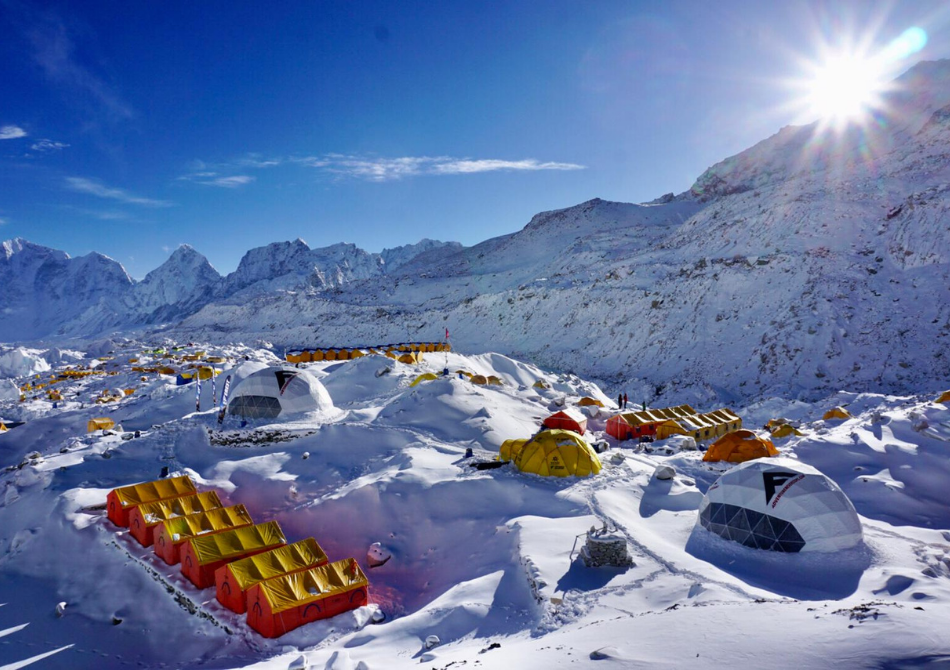
- Everest Base camp is situated on the north of Khumbu glacier at high of 18000ft. All the international Mt. Everest climbers assemble here during the starting and at the ending time of their climbing. Normally the climbing duration of this expedition lasts for 90 days. All the climbers who mass there at the base camp seem really busy with excitement for the preparation of their expedition to reach on the summit.
- North Face Tents Some climbers climb this mountain on their own risk without any climbing Sherpa guide; and some climbers go with their own climbing Sherpa guide. Most of the teams carry out their own Internet, Satellite phone, Medical Doctor and rest of the modern requirement.
- After the Base camp, we have to cross crevasses, Seracs and ice block. Similarly, we should face to the way up having Chunks of ice as large as our houses where we should use fixed ropes and aluminum ladders to climb ahead camp 1st 6400m.
Camp 1: 20000ft. (6,400m)
This camp 1 is situated at the flat area of endless snow deep crevasses and mountain walls. Because of the Sun’s reflection from this place, we get warm and heating ambience at this place. In the night we listen the deep murmuring cracking sounds of crevasses beneath our tent. These are the areas where we have to walk to reach camp 2.
Camp 2. 21000ft. (6,750m)
This camp 2 is situated at the height of the 21000ft, which is located at the foot of the icy mount Lhotse wall though where we have to go ahead. Weather is here is good but bad clouds roll in from the low range of the Himalayan valleys to the bottom of our camp two. But wind here sometimes seems very violent enough to destroy our tents. After climbing these palaces, we reach camp 3.
Camp 3. 22300ft. (7,100m)
Camp 3 is located at the height of 22300ft, adjoining to mount Lhotse wall. After climbing the 4000ft. Lhotse wall by using fixed rope and with prior acclimatization it leads us to camp 4. Also, on the way we have to ascend the steep allow bands (lose, down slopping and rotten limestone). From their crossing short snowfield, the route moves ahead up the Geneva Spur to the east before finishing the flats of the south col. (Another wells name meaning Saddle of pass). Oxygen should probably be use above base camp 3 in case of needed to the climbers.
Camp 4. 26000ft. (8,400m)
Now we are on camp 4 which located at the height of 26000ft; it is the last camp of the Expedition. From here summit is about 500m, distance far. This is the final and dangerous part of the climbing. This place is besieged by ferocious and violent winds. The normal best way to reach the summit is via the narrow South – East Ridge and it precedes the South Summits 28710ft. From here the way is easy to reach at the summit of the Everest 29028ft; and late Sir Edmond Hillary and l Tenzing Norge Sherpa used this route in 1953.
Itinerary
Upon your arrival at the TIA, you will need to fulfill some official procedures to obtain the Nepal Entry Visa at the Immigration counter. One of our Nomadways Adventure representatives will be waiting to welcome you at the Arrivals. After the meet and greet, you will be transferred to the hotel.
Meal :
Breakfast, Lunch, dinner
Accommodation :
At a Luxury Hotel/Guest house
On the second day, we will fulfill all our official procedures including necessary documentation, obtain permits, and other formalities needed for our expedition. Then you will have time for sightseeing around the city.
The next day, we will start our preparation for our expedition. We will now pack our bags, do some necessary shopping, and re-check everything that we need (Especially medicines and essentials). Briefings will be made about every aspect of the expedition and all gear and equipment, trip duration, accommodation, facilities at the base camp, and all related to the expedition. It is also an opportunity for you to communicate and introduce yourself to your fellow climbers and teammates.
Meal :
Breakfast, Lunch, dinner
Accommodation :
At a Luxury Hotel/Guest house/Camp
After an amazing breakfast, we will take a thrilling flight to Lukla Airport early in the morning. The flight gives you a bird’s eye view of the valleys, rivers, hills, and gradually mountain ranges. Even though the flight is only for half an hour, it does not fail to mesmerize you now and then. As we land at Lukla Airport, which is already exciting, we start our trek to Phakding, our destination for the day. After obtaining the permit for the region, we will slowly move through the settlements on a mixed trail of dirt, stone pathways, and some rocky sections at times. This is an easy start, so make sure to enjoy all the greeneries, floras, and faunas as you walk. The trail takes you over several suspension bridges and along the Dudh Koshi river. Enjoy the rest of the day at Phakding.
Meal :
Breakfast, Lunch, dinner
Accommodation :
At a Luxury Hotel/Guest house/Camp
After Phakding, we move towards another beautiful destination, Namche Bazaar, which is the commercial point of the Khumbu region. Passing through the dense luscious forests of pine, juniper, and Rhododendron, looking out for animals in the Sagarmatha National Park, climbing the stairs, enjoying the rages of rivers at some points, and mostly walking uphills are the major activities of the day’s trek. This trek will be long and tiring as we start gaining significant elevation. As we reach Namche, we rest at our hotel and enjoy our dinner. The next day, we will hike up to Everest View Point 3900m to acclimatize & return back to the hotel then in the evening time we can go around the village area and experience some local sherpa culture. We can also visit the Everest Photo Gallery and the Sherpa Museum while in Namche.
Meal :
Breakfast, Lunch, dinner
Accommodation :
At a Luxury Hotel/Guest house
Rest and acclimatization at Namche, we then approach one of the most beautiful and tranquil parts of this Expedition, the Tengboche monastery. Tengboche monastery is one of the most popular monasteries among Buddhists around the world. The views of Mt. Everest, Nuptse, Lhotse, and Ama Dablam are visible towards the north while Thamserku and Kangtega stand towards the south with striking views. We will also join in some prayer ceremonies and rest for the day.
Meal :
Breakfast, Lunch, dinner
Accommodation :
At a Luxury Hotel/Guest house/Camp
After rest day at Namche Bazaar, we will trek to Debuche (3,860 m).
Meal :
Breakfast, Lunch, dinner
Accommodation :
At a Luxury Hotel/Guest house/Camp
After spending our night in Debuche (3,860 m), we start our trek towards Dingboche where we will stay for the next day to acclimate ourselves. Following the path down from Tengboche towards Deboche through the forests of Rhododendrons, we cross a bridge over the raging Imja river. Then we gradually climb uphill to reach the village of Lower Pangboche where we can witness the spectacular views of Ama Dablam. We then move across the valley to reach our destination Dingboche at the start of the Imja Tse valley after an approximate walk of 5-6 hours. We spend our next day here to acclimate ourselves. We go on short hikes around the area to get some striking views of the mountain grandeur.
Meal :
Breakfast, Lunch, dinner
Accommodation :
At a Luxury Hotel/Guest house/Camp
We will have a good rest at Dingboche and then move across the valley to reach our destination Dingboche at the start of the Imja Tse valley after an approximate walk of 5-6 hours. We spend our next day here to acclimate ourselves. We go on short hikes around the area to get some striking views of the mountain grandeur.
Meal :
Breakfast, Lunch, Dinner
Accommodation :
At a Luxury Hotel/Guest house/Camp
Our next destination is Chhukung, a small village away from the regular crowded route of the Everest Region. From Dingboche, after breakfast, we start our trek alongside the river down the valley, passing through the settlements of Dingboche. Walking on trails of dirt, rocks, and sand, witnessing the stunning views of Ama Dablam, Lhotse and Nuptse in the background, we finally reach Chhukung to rest overnight. Chhukung houses only a few teahouses to serve the climbers and trekkers heading to Island peak, Chhukung Ri and Kongma La Pass.
Meal :
Breakfast, Lunch, Dinner
Accommodation :
At a Luxury Hotel/Guest house/Camp
The trek from Chhukung valley to the Island Peak base camp takes about 5 hours on rugged and rocky terrain. The trail passes through the Imja river leading to the Lhotse Glacier, showcasing some magnificent views of surrounding peaks. Enjoy the overwhelming beauty and tranquility of the area as it rejuvenates the inner soul of every traveler. We set up our base camp at 4970 m so that we can acclimatize ourselves.
Meal :
Breakfast, Lunch, Dinner
Accommodation :
At a Luxury Hotel/Guest house/Camp
From the base camp, we will ascend towards the high camp at 5600 m. The trail is steep and tough as it gets narrower as you approach the high camp. We will take a day’s rest at the high camp for acclimatization.
From the high camp, we climb up on steep slopes that lead to the glaciers. Walking on the ridges along the glacier and crossing some steep slopes of snow and ice, and traversing some crevasses, we finally reach the summit of Island Peak or Imja Tse at 6189 m. The climb requires us to walk with the fixed ropes, use ice-ax and crampons and climb up the ladder at times. The struggle is real but it’s worth it. You will have climbed one of the snow-capped peaks above 6000m and stepped into the alpine zone. The beauty of the mountain ranges that one can see from the summit is out of the world. It feels like you are standing on the top of an island beholding the vast sea of ice and snow with other peaks peeking out. After spending some time at the Summit, capturing some unforgettable memories of the Khumbu Region, we retrace our steps back to the Base Camp.
Meal :
Breakfast, Lunch, Dinner
Accommodation :
At a Luxury Hotel/Guest house/Camp
Descend to Dingboche & rest day.
Meal :
Breakfast, Lunch, Dinner
Accommodation :
At a Luxury Hotel/Guest house/Camp
After climbing the Island Peak, we will then head to Lobuche. You will encounter a series of stone monuments made in the memories of climbers who couldn’t make it back home. After walking for almost 6-7 hours on rugged terrain we reach Lobuche, a small settlement of Sherpas. It is the final village with lodges on this trail to Everest.
Meal :
Breakfast, Lunch, Dinner
Accommodation :
At a Luxury Hotel/Guest house/Camp
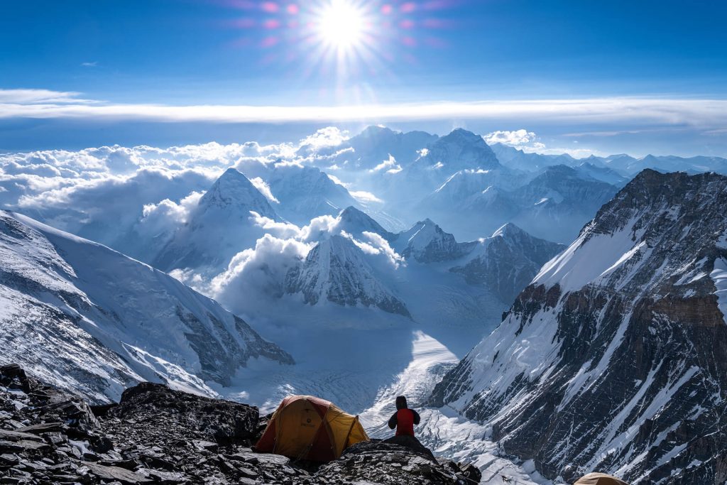
After Lobuche, we follow the Khumbu Glacier to reach Everest Base Camp. Enjoying the grand views of Mt. Everest, Lhotse, Nuptse, Ama Dablam, and many others in the background we finally reach the base of the world’s highest mountain. We will spend quite a few days in the base camp, training, acclimatizing, and preparing for the summit. We go on short excursions, practice through the Khumbu Icefall climb, and get acquainted with crampons, ice axes, and other climbing gears. We go on rotations to prepare to climb to Camp 1.
Meal :
Breakfast, Lunch, Dinner
Accommodation :
At a Luxury Hotel/Guest house/Camp
During the five-day period, we carry out the following activities:
- Prayer Ceremony
- Training: ladder practice, fixed lines, diagonal ascent/descent, traverse, duck walk, classical/flat footing, using oxygen, etc.
Meal :
Breakfast, Lunch, Dinner
Accommodation :
At a Luxury Hotel/Guest house/Camp
After 4-5 days of training, practicing and rotation, we will finally climb to Camp I to experience the true essence of the expedition. It requires crossing the Khumbu Icefall and tough crevasses. At Camp 1 at 6000 meters, we stay overnight in full-proof tents enjoying the meals cooked by our chefs.
Meal :
Breakfast, Lunch, Dinner
Accommodation :
At a Luxury Hotel/Guest house/Camp
After staying overnight at Camp 1, we gradually ascend towards Camp 2 that is set up at 6400metres. The climb includes crossing the Western CWM, a gently rising valley that is marked by huge crevasses in the center preventing direct access to the upper part of the CWM. In case of favorable weather, we will spend the next day at Camp II for acclimatization.
Meal :
Breakfast, Lunch, Dinner
Accommodation :
At a Luxury Hotel/Guest house/Camp
Climb & touch to camp III (7,200 m) & descend to camp II.
Meal :
Breakfast, Lunch, Dinner
Accommodation :
At a Luxury Hotel/Guest house/Camp
It is necessary to provide our body with some rest after continuous climbing and mountaineering. So, after an overnight’s rest at Camp II, we will descend to the Base Camp, at a much lower altitude. These ascents and descents are a way of acclimatizing ourselves in the Himalayas and training to climb up to Camp IV and above the Death Zone. We will rest overnight at the Base Camp.
Meal :
Breakfast, Lunch, Dinner
Accommodation :
At a Luxury Hotel/Guest house/Camp
We allocate few days of complete rest before actually heading to the summit. For this, we may either descend back to Namche to rest at a cozy lodge or fly back to Kathmandu (For those who can afford it). While at rest, our expedition leaders and the team will evaluate the weather conditions and decide when to go for a final summit push. When everything looks favorable, we will prepare to trek back to the Base Camp. Those who choose to rest in Kathmandu can take Heli or can stay in Base Camp. During these resting period, our teams and climbing sherpas will be setting up higher camps at Camp IV for the summit push.
Meal :
Breakfast, Lunch, Dinner
Accommodation :
At a Luxury Hotel/Guest house/Camp
Our body has been acclimatized, we have been on multiple rotations up to Camp III, climbed on rocks and ice, the weather looks favorable, and is the perfect time for the Summit Push. so, we head back to Base Camp and prepare ourselves for the victory we will be achieving in the next few days.
Meal :
Breakfast, Lunch, Dinner
Accommodation :
At a Luxury Hotel/Guest house/Camp
As we will have already been to Camp II earlier, it will be easier for us to reach there this time. Crossing the Khumbu Glacier and tough crevasses, passing Camp I at5943 meters, we will finally reach Camp II. The climb includes crossing the Western CWM, a gently rising valley that is marked by huge crevasses in the center preventing direct access to the upper part of the CWM. We will rest overnight and enjoy the delicious hot meal prepared by our experienced cooks. Make sure to stay warm and stick with the team.
Meal :
Breakfast, Lunch, Dinner
Accommodation :
At a Luxury Hotel/Guest house/Camp
After resting overnight at Camp II, we will then ascend towards Camp III at 7200metres. Walking on the trail of ice, snow, and rocks, following the fixed ropes set up by our fellow Sherpa Climbers, we reach Camp III. We will use Oxygen Cylinders from here on. We request everyone to remain careful and stick with the team as well as communicate often. We will spend our night in Camp III in a warm tented Camp.
Meal :
Breakfast, Lunch, Dinner
Accommodation :
At a Luxury Hotel/Guest house/Camp
After Camp III, we ascend to Camp IV at 8000m. This is also the divergent point for climbers of Lhotse and Everest. The area above this is called the Death Zone and requires extreme caution and carefulness. We will keep ourselves warm and safe. A day’s rest has been allocated for Camp IV before the summit Day. We will monitor the weather conditions before summiting Everest.
Meal :
Breakfast, Lunch, Dinner
Accommodation :
At a Luxury Hotel/Guest house/Camp
This day is the day when our hard work, patience, endurance comes into reality. We will finally reach the top of the World. We start as early as midnight so that we reach the top at dawn to witness the glorious sunrise from behind the great mountain ranges. We spend some unforgettable moments on the highest point on Earth, take some photographs, and gradually descend to Camp IIIor Camp II to rest overnight. The climbers are only allowed to stay at the summit point for 15-20 minutes for the safety and following the climbing guidelines
Meal :
Breakfast, Lunch, Dinner
Accommodation :
At a Luxury Hotel/Guest house/Camp
After the night’s stay at Camp III or Camp IV, we will follow the way back to Camp II and rest overnight.
Meal :
Breakfast, Lunch, Dinner
Accommodation :
At a Luxury Hotel/Guest house/Camp
From Camp II, we will descend back to the Base Camp and as responsible travelers, we will clean up all the trash around the camp. We will then prepare to trek back to Pheriche.
Meal :
Breakfast, Lunch, Dinner
Accommodation :
At a Luxury Hotel/Guest house/Camp
Clean up base camp.
Meal :
Breakfast, Lunch, Dinner
Accommodation :
At a Luxury Hotel/Guest house/Camp
As a part of our Luxurious Everest Expedition, we will take a direct flight back to Kathmandu. We will then rest at our cozy 5-star hotel and enjoy some delicious cuisines. you will be cordially invited to the Farewell Dinner hosted by the Nomadways Adventure team on this very last night of our Luxurious trip to Everest.
Meal :
Breakfast, Lunch, Dinner
Accommodation :
At a Luxury Hotel/Guest house/Camp
With gratitude and best wishes, we will have to bid you farewell for your flight back home. We hope to see you soon in the next season for a brand new adventure.
Meal :
Breakfast, Lunch, Dinner
Accommodation :
At a Luxury Hotel/Guest house/Camp
Cost Includes:
- All airport transfers
- Luxury Hotel in Kathmandu for two nights with breakfast
- All airport taxes
- All necessary paperwork and trekking permits (National Park permit and TIMS)
- An experienced English-speaking Govt. registered trekking guide and local porters to carry luggage (2 trekkers: 1 porter)
- Full meals: Breakfast, Lunch & Dinner of your choice
- Supplementary snacks: energy bar and cookies
- Seasonal fresh fruits desert every day
- Unlimited Chlorine treated Safe Drinking water
- Accommodation: Lodge
- A comprehensive First Aid kit
- Oxi-meter: To check heart rating and oxygen saturation to Everest Base Camp and return
- All government and local taxes
- Trekking equipment: down-filled sleeping bag, walking poles, and duffel bag
- Souvenir: Trekking Route map printed T-Shirts
Cost Excludes:
- Lunch and dinner in Kathmandu
- Hot and bottled drinks
- Electronic device re-charge Wi-Fi
- Hot shower
- Travel insurance and medical evacuation
- Tipping
Equipment
Trekking requires careful selection of gear to ensure comfort, safety, and efficiency on the trail. Depending on the conditions (terrain, weather, duration), the equipment you need may vary, but here’s a comprehensive list of essential trekking gear:
- Backpack
- Capacity: Typically, for a multi-day trek, a 40-60L pack is ideal.
- Fit: Adjustable straps for shoulder, chest, and hip.
- Features: Hydration system compatibility, side pockets for easy access, and a rain cover.
- Footwear
- Trekking Boots: Look for boots with good ankle support, durable soles (Vibram is a popular choice), and waterproof features.
- Trail Shoes: For lighter treks or well-maintained paths, trail shoes may suffice.
- Sock Layers: Merino wool socks or synthetic socks that wick moisture and reduce blisters. Avoid cotton.
- Gaiters: To keep debris, mud, and snow out of your boots.
- Clothing (Layering System)
- Base Layer: Moisture-wicking (synthetic or merino wool) long-sleeve top and bottoms.
- Mid Layer: Insulating layer, such as a fleece or down jacket.
- Outer Layer (Shell): Waterproof, windproof jacket and pants. Gore-Tex or similar fabrics are excellent choices.
- Trekking Pants: Convertible pants (with zippers for shorts) can be useful.
- Trekking Shirt: Lightweight, moisture-wicking, and quick-drying.
- Gloves: Lightweight gloves for warmth, plus an additional heavier pair if trekking in cold climates.
- Hat/Cap: A sunhat or beanie depending on the weather.
- Neck Gaiter/Buff: For sun protection, warmth, or dust.
- Sleeping Gear
- Sleeping Bag: Temperature-rated for the conditions you’ll face. Down bags are warmer and lighter but lose effectiveness if wet, while synthetic bags dry quicker.
- Sleeping Pad: Inflatable or foam pads that insulate from the cold ground.
- Tent: Lightweight trekking tents (1-3 person) that suit your conditions. Some options include 4-season tents if you're trekking in harsh weather.
- Hydration System
- Water Bottles: Collapsible or hard plastic bottles (ensure they’re BPA-free).
- Hydration Reservoir: Camelbak or similar bladder systems for easy access to water.
- Water Purification: A filtration system (e.g., Sawyer, LifeStraw) or chemical tablets to purify water from streams or other sources.
- Food and Cooking
- Stove: Compact gas or alcohol stove for cooking on the trail.
- Cookware: Lightweight pots or pans, often titanium or aluminum.
- Fuel: Compatible fuel for your stove (check for availability in the region you’re trekking).
- Food: Dehydrated meals, energy bars, trail mix, nuts, and fruits. Lightweight, high-calorie, and easy-to-prepare foods are best.
- Navigation Tools
- Map and Compass: Always have a paper map as a backup, even if you use a GPS.
- GPS Device or Smartphone with a Trekking App: Make sure to download offline maps.
- Altimeter Watch (optional): Useful for tracking elevation and route progress.
- Lighting
- Headlamp: Hands-free lighting for night-time use, with extra batteries.
- Flashlight: A backup to your headlamp.
- First Aid Kit
- Include basic supplies: Bandages, antiseptic wipes, blister treatment, pain relievers, and any personal medications.
- Personal Medications: Always bring enough for the whole trip, plus extras in case of delays.
- Sunscreen and Lip Balm: Protect your skin from sun exposure.
- Safety Gear
- Multi-tool/Knife: A good multi-tool (like a Swiss Army Knife or Leatherman) is very useful for repairs and emergencies.
- Whistle: For signaling.
- Emergency Blanket: Lightweight and compact for warmth in case of emergency.
- Firestarter: Matches or a lighter, and waterproof if needed.
- Miscellaneous
- Trekking Poles: Help with balance, reduce strain on knees, and improve traction on uneven terrain.
- Towel: Quick-dry, compact towel.
- Sunglasses: UV protection for your eyes.
- Camera/Smartphone: For documenting the journey, with extra storage or a portable charger.
- Personal Hygiene and Toiletries
- Toilet Paper: Always carry biodegradable toilet paper and a small trowel for digging a "cathole" if there are no facilities.
- Hand Sanitizer: To keep clean without access to water.
- Wet Wipes: For cleaning yourself when there's no shower.
- Biodegradable Soap: If you need to wash, use eco-friendly soap.
- Toothbrush/Toothpaste: Compact travel versions.
- Weather Protection
- Sun Protection: Sunglasses, sunblock, and a wide-brimmed hat for sun protection.
- Rain Gear: A high-quality waterproof jacket, pants, and gaiters, especially if you're trekking in areas with unpredictable weather.
- Cold Weather Gear (if needed): Depending on the trek, you might need additional gear like down jackets, insulated gloves, or even crampons for ice or snow.
- High-altitude Treks: Consider gear for altitude sickness (like Diamox), extra layers for extreme cold, and an oxygen system if necessary.
- Long-distance Treks: You might need additional gear like extra food storage, a larger stove, or a lightweight trekking umbrella.
FAQ's
An average expedition to summit Everest lasts around 65-70 days. This includes time for acclimatization, resting, waiting for the right weather conditions, and climbing to the summit and back.
Climbers follow the principle of "climb high, sleep low." This means they ascend to a higher camp, spend some time there, and then return to a lower camp to sleep. This gradual ascent helps their bodies adjust to lower oxygen levels.
The best times to summit Everest are during the pre-monsoon season (late April to early June) and post-monsoon season (late September to early October). Most climbers attempt to summit in May, as the weather is typically more stable.
Most climbers use supplemental oxygen above 7,500 meters (24,600 feet) because the air is too thin to support sustained human life. This is critical for the final push to the summit, where oxygen levels are just one-third of what they are at sea level.
Map
Consumer reviews
Similar Trips

Don’t wait any longer. Contact us!

Mail us on

Affiliation